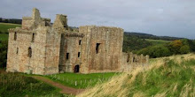
Not many people go to Roxburgh Castle nowadays. It's a nice walk along the Borders Abbeys Way where Teviot joins Tweed, but nothing much to see...
In most history books it is only referred to as the place where King James II of Scotland was killed in 1460 by his own cannon exploding beside him (his nine year old son was then crowned James III in Kelso Abbey).
But before it was destroyed, Roxburgh Castle and its associated town to the east on what is now Friars Haugh, were a significant centre of power. In the time of King David I it was for a time the de facto capital of Scotland.
In the Middle Ages the town had as much importance as Edinburgh, Stirling or Perth; indeed it was the first recorded Scottish burgh. Situated on the Tweed, upstream from the major port of Berwick, and close by Dere Street, it was a substantial market town, exporting large quantities of raw wool and hides to Bruges, Ghent and beyond.
At that time the castle may have looked like this (with thanks to Andrew Spratt).
Roxburgh has also been closely associated with King Arthur, inspiring leader of a well disciplined mounted force that won a reported 13 battles, mostly in the lands north of Hadrian's Wall.
Writing about Roxburgh in his 'History of the Borders', historian Alistair Moffat writes, "Cavalry forts have special requirements and the castlemount and the wide haughland between the Tweed and the Teviot provide all of them...The ancient Celtic name of Roxburgh Castle was preserved and before the Angles came to change it, it was called Marchidun: in Old Welsh, the Horse Fort. Medieval and modern Arthurians would have preferred to call it Camelot."
Subscribe to:
Post Comments (Atom)




No comments:
Post a Comment